


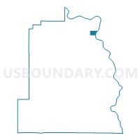
Swallows Nest Voting District, Asotin County, Washington
About
Outline

Summary
| Unique Area Identifier | 683400 |
| Name | Swallows Nest Voting District |
| County | Asotin County |
| State | Washington |
| Area (square miles) | 1.33 |
| Land Area (square miles) | 1.33 |
| Water Area (square miles) | 0.00 |
| % of Land Area | 100.00 |
| % of Water Area | 0.00 |
| Latitude of the Internal Point | 46.36789670 |
| Longtitude of the Internal Point | -117.07615580 |
Maps

Graphs
Select a template below for downloading or customizing gragh for Swallows Nest Voting District, Asotin County, Washington


Neighbors
Neighoring Voting District (by Name) Neighboring Voting District on the Map
- Clarkston Heights 3 Voting District, Asotin County, WA
- Clarkston Heights 4 Voting District, Asotin County, WA
- Clarkston Heights 5 Voting District, Asotin County, WA
- South Clarkston 2 Voting District, Asotin County, WA
- Water: Snake River, Asotin County, WA
- West Asotin Voting District, Asotin County, WA